Ecopia AI & Nearmap Launch Off-the-Shelf Advanced Transportation Feature Data Across North America
January 20, 2026 - Ecopia AI announces the release of high-precision planimetric transportation data across North American cities, extracted from Nearmap aerial imagery to support mapping analytics in civil engineering and the public sector.
January 20, 2026 - Toronto - Ecopia AI (Ecopia), in partnership with Nearmap, announces the release of high-precision planimetric transportation data across 100 North American cities. This data is available for instant access to support transportation and mapping analytics for federal, state, and local government organizations, as well as civil engineering firms.
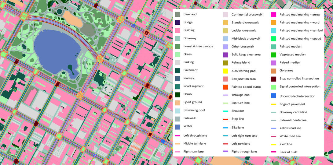
Building upon the creation of off-the-shelf 2D and 3D land cover data across North American population centers, the Advanced Transportation Features dataset provides comprehensive, accurate, and up-to-date geospatial context for initiatives such as urban planning, traffic safety, and bike/pedestrian network access.
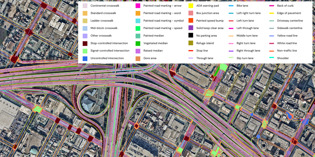
To create this unprecedented dataset, Ecopia’s AI map engine extracted 60+ individual vector layers from Nearmap’s high-resolution aerial imagery, including sidewalks, bike lanes, turn lanes, road markings, crosswalks, and more. Initially extracted for 100 cities, this data will be expanded to Nearmap’s entire coverage area (more than 1.5 million square kilometers) in the coming months.
“Transportation infrastructure is some of the most complex and detail-rich data to create at scale,” said David Tobias, Chief Product Officer at Nearmap. “By combining Nearmap high-recency aerial imagery, AI-derived attributes, and consistent coverage with Ecopia’s advanced feature extraction, we’re enabling a new level of transportation intelligence that helps organizations move faster, reduce uncertainty, and plan with confidence.”
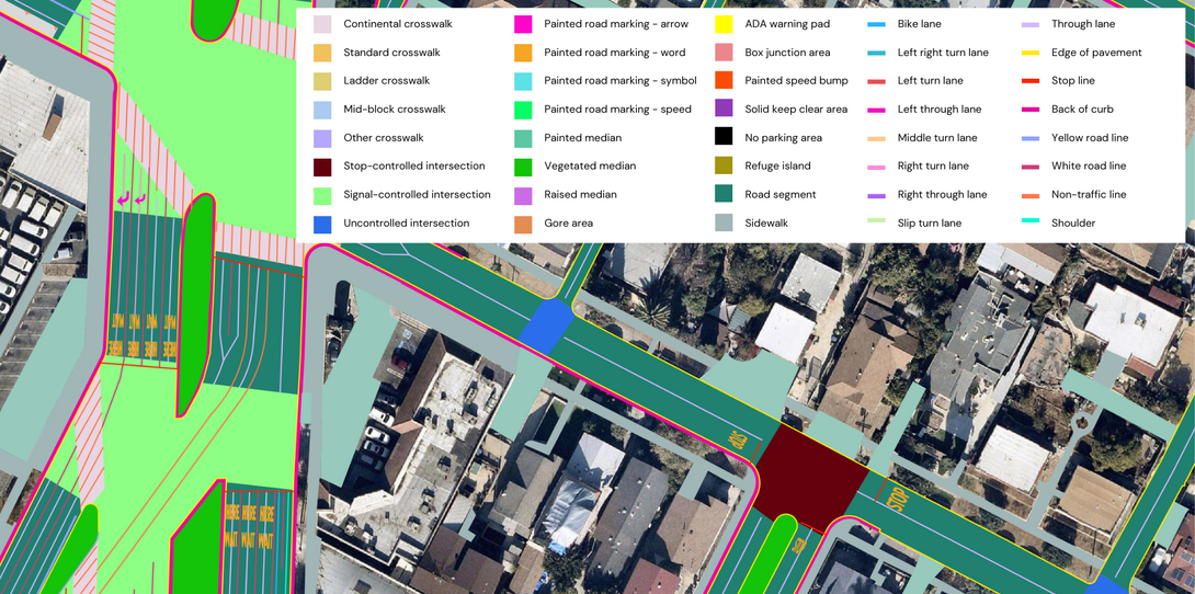
Unlike other automated mapping solutions that sacrifice data quality for scale and speed, Ecopia’s systems produce planimetric-level map data with >95% geometric accuracy while benefiting from the efficiency of AI - alleviating the challenges of traditional transportation map data creation.
The tedious nature of manually tracing and classifying road lanes, sidewalk networks, and other highly detailed transportation features has made such data difficult to procure, especially at large scales. Providing the cutting-edge Advanced Transportation Features dataset off-the-shelf removes this barrier for civil engineering and public sector organizations alike, empowering them to leverage standardized, high-precision data that accurately reflects real-world conditions.
“The off-the-shelf availability of Ecopia's land cover and transportation infrastructure can be a transformative change in our assumptions of the data available for many planning projects ranging from resiliency to active transportation plans," said David Wasserman, Civic Analytics Leader at Alta Planning + Design. "This type of geospatial data has not existed in an integrated fashion at this scale before. These datasets can jump-start a number of projects that were previously hard to conceive without hours to days of tedious digitization. Sidewalk inventories alone are an area where our profession has made many excuses not to collect, but with this release, some baseline understanding of sidewalk connectivity across entire regions could be made available at low cost. That alone is a huge step forward for transportation planning practice.”
Over the past several years, Ecopia has provided Advanced Transportation Features on a custom project basis to commercial and government organizations, including the Chicago Metropolitan Agency for Planning, the Oregon Department of Transportation, Fehr and Peers, Pima Association of Governments, the City of Los Angeles, and Alta Planning + Design. The off-the-shelf launch of this data represents a key milestone in the geospatial industry, delivering the first-ever standardized inventory of North American transportation infrastructure.
“Launching Advanced Transportation Features for instant access is another step forward on our mission to create a digital twin of the world with AI-powered geospatial data,” said Jon Lipinski, Co-Founder and President of Ecopia AI. “Transportation data is notoriously difficult to create and maintain, especially at large scales, and we are excited to empower more organizations with the data needed for safer, more sustainable communities.”
To learn more about the off-the-shelf Advanced Transportation Features dataset, click here.
****
About Ecopia AI
Ecopia is on a mission to create a digital twin of the Earth. We leverage artificial intelligence to convert high-resolution imagery into high-precision 3D vector map data at scale. This data creates a digital representation of the physical world, forming the foundation of a digital twin for visualization, analytics, and decision-making. Ecopia’s data is leveraged by hundreds of commercial and government organizations across more than 100 countries around the world.
About Nearmap
Nearmap is the property intelligence provider customers rely on for consistent, reliable, high-resolution imagery, insights, and answers. Harnessing its own patented camera systems, imagery capture, AI, geospatial tools, and advanced SaaS platforms, Nearmap users receive tailored solutions for complex challenges. Nearmap captures wide-scale urban areas in the United States, Canada, Australia, and New Zealand several times each year, making content instantly available in the cloud via web app or API integration. Founded in Australia in 2007, Nearmap stands as the definitive source of truth that shapes the liveable world. For more information, please visit www.nearmap.com.
Learn more about Ecopia
News
Digital Twin
3D Land Cover Data from Ecopia AI Now Available for Instant Access Across 400 US Cities

News
Digital Twin
Ecopia AI Provides High-Precision Mapping Data for NVIDIA Earth-2 Climate Digital Twin Cloud Platform

News
Transportation Planning
South Central Planning and Development Commission Selects Ecopia AI to Support Transportation Planning

Blog
Transportation Planning
Mapping What Matters: Building Safer Transportation Systems with Pedestrian Asset Data


Ready to get started?
Get in touch with our team and explore our data portal.